Santa Cruz Mountain Fire Maps
Here is a roundup of maps you might find useful, and some alternates just in case the one you are trying to load won’t work! Remember that all fire maps are definitionally out of date so don’t rely on them for life and death decisions.
TUESDAY AUGUST 25, 2020: I have suspended updating the screencaps in the post below. Use the links to check out the most current data.
1. Cal Fire Map [link]
This is the most authoritative map, but fires are represented by icons and do not display the current footprint of the fire. Follow Cal Fire on Twitter, where they post updated fire footprints around 7am/7pm each day following the press briefings at 6.
DIRECT LINK: https://www.fire.ca.gov/incidents/
Small icons represent each fire. Hover over each to view current stats, evacuated neighborhoods and links for more details.

Screencap of the Cal Fire site, which uses icons to represent fires.

Click on a fire icon in order to access stats and more information.
UPDATED Perimeter Maps and video clips from the 6am August 23, 2020 press briefing.

#CZULightningComplex Sunday Perimeter Map posted 9:31 AM · Aug 23, 2020 by Cal Fire CZU
This is low res and hard to read. Cal Fire sometimes shares High Res images. If you are trying to find them, look for “Perimeter Maps” in your Cal Fire emails. Their social team sometimes posts links to high res versions on Twitter: look for “Constant Contact” urls generated by their email software.
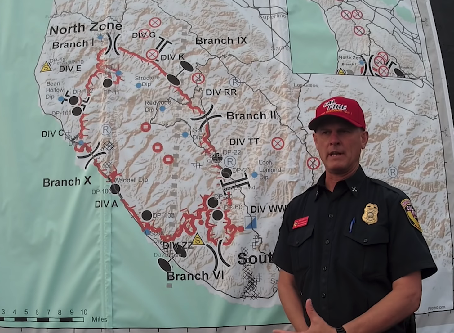
Battalion Chief Mark Brunton explains some of the Fire Map symbols:
- Red circle with three horizontal lines: High Hazard, stay away
- Straight Brackets: Breaks between the “branches” of the fire e.g. |—|
- Curved Brackets: Indicates separate “divisions” used internally to organize firefighter teams e.g. )(
- Circle with an X: Traditionally the origin of the fire. These represent initial lightning fires where firefighters were first deployed. Still on the map for monitoring in “patrol status” (yes the XMEN logo)
- Square with blue and white triangles: Incident command post, currently SkyPark in Scott’s Valley
- Blue Dots: Water locations that helicopters use
2. Santa Cruz Mountains Fire Evacuations Google Map [link]
via Mercury News
This Google Map is updated regularly and shows both the known footprint of the fire as well as the surrounding evacuations.
HOW TO USE: Once you load this map in another window, look for the STAR icon. Hit that and this map will be saved to your Google Maps.
Google Maps > Menu > Your Places > Maps tab.
DIRECT LINK: https://www.google.com/maps/d/viewer?mid=1SDLnNiuBi-poT5gdfsrvvSbXYIk_kQwI&ll=37.17632872846762%2C-122.19467725&z=10
3. Current Santa Cruz Mountain Evacuation Zones [link]
Find out what code your neighborhood is in and cross reference this with Cal Fire Press Releases.
DIRECT LINK: https://storymaps.arcgis.com/stories/f0121f7f2f0941afb3ed70529b2cee75
HOW TO USE: The dark outlined area represents the boundary of the fire reported several hours earlier. It will always be somewhat out of date so don’t rely on this!
Zoom into your area to find your zone/code, which Cal Fire will reference in their PDF Press Releases for evacuations.

Current as of 8pm Sunday August 23, 2020

Closeup of the new Evacuation WARNING zones added 7:30pm Sunday August 23, 2020. -CALFIRECZU

Current as of 8pm August 23, 2020. No warnings for Santa Cruz.

an example CAL FIRE Press Release, referencing neighborhood codes.

4. NASA Fire Data [link]
NASA has a sat camera with current fire data. Zoom into your local area to find the red blocks representing various fire reports.
DIRECT LINK: https://firms.modaps.eosdis.nasa.gov/map/#t:adv;d:2020-08-22..2020-08-23;@-122.0,37.0,11z
HOW TO USE: You’ll see on the right dashboard that there are four types of data inputs, and some options to customize your map view. But you don’t need to touch any of that stuff if you’re not interested — just visit the website, and use the PLUS and MINUS icons on the top left to zoom around the map.
Make sure that the DATE is current in the right panel.

Screencap 2pm August 23, 2020
5. Live Aircraft Maps [link]
Spot firefighting planes and helicopters over the mountain fires.
DIRECT LINK: https://www.flightradar24.com/37.14,-122.18/11
FlightRadar.com publishes real-time global flight tracking.
H/T to Stephen Baxter

EXAMPLE SCREENCAP. 3:30pm August 21, 2020. Visit their website for real time flight data.
Not sure of the origin of this map but it is a good backup if you are having trouble loading the others.
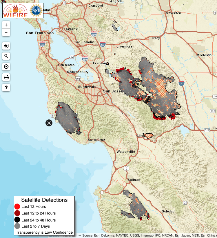
Current as of 2pm Sunday August 23, 2020 The colors represent the recency of the satellite detections, with gray being the oldest, and bright red representing the (current)ish data.
7. CAL TOPO [link]
See changes in temperature over time, and keep an eye on winds
DIRECT LINK: https://caltopo.com/map.html#ll=37.10256,-122.1484&z=11&b=om&o=r&n=0.01&a=modis_vp%2Cwxd_wspd-01
This is probably my favorite map to date. I believe it is utilizing the NASA data sources referenced above. Toggle the FIRE ACTIVITY dropdown between VRIIS 375m and VIIRS Progression. Use the NWS Forecast Grid to layer in future wins speeds.
I can’t vouch for accuracy, but the progression view should illustrate the footprint of the fire by date, while the 375m would illustrate current heat measurements.
Combine this with wind data for a fuller picture.

Current as of 2pm Sunday August 23, 2020. Use MAP LAYERS to customize your view.
“If you are planning your evacuation route today, check on neighboring fires in San Jose, Carmel/Salinas, Napa and Big Sur.”
8. San Jose Evacuation Maps [link]
Check neighboring fires across your evacuation route.
DIRECT LINK: https://milpitas.maps.arcgis.com/apps/webappviewer/index.html?id=f5f17191244d424fa569cfec51fc3535
East San Jose is evacuating as far south down the 101 to Gilroy

Current as of 2pm August 23, 2020
9. Carmel, Salinas, Big Sur Evacuation Maps [link]
This map shows the neighborhoods under evacuation for the Carmel Highlands, Carmel Valley, Salinas, and Big Sur.
DIRECT LINK: https://www.arcgis.com/apps/webappviewer/index.html?id=905a9458324b4868804d96b5593eb978
Carmel/River fires are expected to merge & impact 101.

The Evacuation Warning for Zone 24 includes the Arroyo Seco Resort and Recreation Site/Campgrounds; The map has been updated to reflect this inclusion. The Pine Canyon Road referenced in the areas east of Junipero Serra Peak is outside of King City. Posted 9:08 PM · Aug 22, 2020 by Monterey County Office of Emergency Services.

Current as of 2pm Sunday August 23, 2020.
10. Napa Valley Fire Evacuation Map [link]
DIRECT LINK: https://sonomacounty.maps.arcgis.com/apps/webappviewer/index.html?id=69a0e54e9e2b48c086d122027b21c961&fbclid=IwAR3P0D9CfGUeINhA5GBAihz3MaBcS-UqgFLfgZWuXSwD_FcyFsHat9cHcq4
If your destination is to the north, check on the Napa fires to the Northwest of Santa Rosa and Northeast of Calistoga:

Current as of 2pm Sunday August 23, 2020.
More information about the Santa Cruz Mountain Fires